

Showing posts with label weather. Show all posts
Showing posts with label weather. Show all posts
Saturday, February 2, 2019
Friday, June 2, 2017
Learn about Space Weather with the SUN SERIES
Staff Writer, DL Mullan
Science / Heliosphere
________________________________
Source: Suspicious Observers
Science / Heliosphere
________________________________
Since there are many questions about how weather and climate are created, here are a few videos to help mitigate the confusion:
The Sun Series
The Sun Series
Source: Suspicious Observers

Wednesday, June 29, 2016
The Monsoon and Unhealthy Ozone
Staff Writer, Nathaniel Diaz
Weather / Air Quality
________________________________


Source: AirNOW, Weather Underground
Weather / Air Quality
________________________________
Ozone will be a problem again in the unhealthy range. So people with respiratory issues should limit activity. Healthy people should take caution as well.

Will the monsoon come and alleviate the unhealthy air quality?
Forecast Discussion: Ozone has been exceptionally high the past couple days as a monsoonal high pressure has persistently remained over the Four Corners region. This system has resulted in an easterly, upper-level flow over the Valley, which acts to "lock" ozone over central parts of the Valley and allows it to accumulate. Nine Valley monitors exceeded the health standard yesterday. Looking ahead, a ridge of high pressure is forecast to remain situated over the Southwest for the next several days. Consequently, the atmosphere over the Valley is expected to be stagnant and support ozone accumulation. Hence, the ozone High Pollution Advisory (HPA) has been extended into Thursday. It is likely that an HPA will be issued for Friday, depending on timing of thunderstorm activity. Regarding thunderstorms, thunderstorms are likely to develop each day over the higher terrain in southeast Arizona and to the north/northeast of Phoenix. Due to the very moist atmosphere over much of south central Arizona, these storms will have to the potential to reach the Valley. For today, there is agreement in high resolution models that a strong outflow could impact the Valley from the south later this afternoon. This would result in blowing dust impacting the Valley. Elevated PM-10 is thus possible this evening. Any rain will help to shut down PM-10. Blowing dust will continue to be a possibility each afternoon/evening this week. Check back tomorrow for the next air quality forecast...
Storms are expected around the metro area for the next few days and into the first of July.

Hopefully these storms produce enough rain to clean the air, wet the land, and keep ozone at bay.
Source: AirNOW, Weather Underground
Monday, June 13, 2016
Correlation Analysis for Total Electron Content Anomalies
Staff Writer, Nathaniel Diaz
Ionosphere / Electrons / Physics
____________________________________
Source: ARXIV,
Ionosphere / Electrons / Physics
____________________________________
Read the Source for the entire scientific paper.1. Introduction
Ionosphere is a shell of a large amount of electrons and it is disturbed by various causes such as volcanic eruptions [Heki, 2006;Dautermann et al., 2009], solar flares [Donnelly, 1976], earthquakes [ Cahyadi and Heki, 2015], and so on. Analyzing Total Electron Content (TEC) data is one of the most popular method to monitor the ionosphere. TEC data contains the number of electrons integrated along the line of sight between the GNSS satellites and the observation stations on the ground. Japan has a dense GNSS observation network (the GNSS earth observation network, GEONET) to collect daily TEC.
Source: ARXIV,
Tuesday, June 7, 2016
High Ozone, SRM, and the Monsoon
Staff Writer, Nathaniel Diaz
Weather / Monsoon _____________________________________
The Sonoran Desert is alive with Health Watches for the high ozone as well as the high temperatures. Since we had such a cool May, June has made up for it in the first half of the month so far. The heat drives our monsoon flow. So the hotter the desert floor: the better our rain chances in the coming months.
Solar Radiation Management has been deployed since there are chances for a sprinkle this week with some monsoon action to our south. March 2016 was a horrible month for climate engineering. There was not a day empty of the toxins. April saw some action. May was devoid of most geoengineering. With rain chances back in the forecast, toxic lines in the sky have reemerged.
Here is the Ozone and weather forecast from AirNOW:
Forecast Discussion: The Humboldt Mountain Monitor located northeast of the Valley recorded an exceedance of the federal health standard yesterday. Here in the Valley, several monitors reached Health Watch (HW) criteria. As for today and tomorrow, even more stable conditions than yesterday will likely result in more ozone accumulation. Therefore, we have an ozone High Pollution Advisory (HPA) in effect through tomorrow (Wednesday). Currently it looks like there will be some improvement on Thursday with ozone levels expected to stay slightly below HPA levels. However, we do anticipate a Health Watch will still need to be issued for Thursday. PM-2.5 has been hovering in the upper Good range the last several days and we don't expect that to change. There are several large wildfires throughout the state, but no significant impacts are expected here in the Valley. PM-10 has thrown a slight curveball today. Local activity near the West Chandler monitor this morning has resulted in elevated concentrations. As a result, PM-10 at that monitor will likely end up near the mid-Moderates for today. Given the localized nature of the elevated PM-10 levels, we will not make a last minute adjustment to today's forecast. As for Thursday, thunderstorms in southern Arizona could create outflows that cause gusty winds here in the Phoenix area, potentially kicking up dust. However, at the moment, our confidence in the strength of the outflows reaching the Valley is not very high. Therefore, for now we will keep PM-10 in the Good range and re-evaluate the situation tomorrow.
Source: AirNOW
Wednesday, May 25, 2016
New Sunspots, Tornado/Storms, UKfrack
Staff Writer, Nathaniel Diaz
Weather / Astrophysics _______________________________
Tuesday, April 26, 2016
CHs Face Earth, Tornado Alert
Staff Writer, Nathaniel Diaz
Astrophysics /Weather ___________________________________
Today's Featured Links:
Dust: https://weather.com/news/news/blowing...
ProtoDisk: http://www.eso.org/public/news/eso1611/
Source: Suspicious Observers
Wednesday, April 20, 2016
Chemtrail Lawsuit to Stop Damaging Spraying Filed in Canada
Staff Writer, DL Mullan
GeoEngineering / Lawsuits
_______________________________
Source: Greg Hunter
GeoEngineering / Lawsuits
_______________________________
Scientists who would like to speak out about the harmful effects of climate engineering (chemtrails) are being threatened and gagged as geoengineering researcher Dane Wigington points out, “U.S. government scientists have no First Amendment protection--none. Now, there is a federal gag order on all National Weather Service and all NOAA employees. How much more obvious is this situation, and they are trying to plug leaks in the ship. We have environmental scientists being fired all over. Canada has let go a huge number of their scientists. Australia has fired 450 of their front line environmental scientists. Why? Because they want to cover up what’s happening any way they can.”
Now, Wigington and others have filed the first of many lawsuits starting with Canada over damage caused by geoengineering (chemtrails). Wigington contends, “They are trying to obscure the severity of what is unfolding from the public for as long as possible. If we don’t take care of what is happening in our skies and environment, nothing else is going to matter. . . . Nothing is going to matter soon. That’s how bad it is. . . . What our government and other governments are doing is to try to hide the magnitude of what is unfolding until the last possible moment, at which time total collapse ensues.”
Join Greg Hunter as he goes One-on-One with Dane Wigington, founder of GeoEngineeringWatch.org.
Monday, April 18, 2016
BIG M6 Solar Flare, New Earth-like Planet
Staff Writer, Nathaniel Diaz
Space Weather / Astrophysics
_______________________________
BIG M6 Solar Flare, New Earth-like Planet
Earth-Like Planet: http://arxiv.org/pdf/1604.04544v1.pdf
Source: Suspicious Observers
Space Weather / Astrophysics
_______________________________
BIG M6 Solar Flare, New Earth-like Planet
Earth-Like Planet: http://arxiv.org/pdf/1604.04544v1.pdf
Source: Suspicious Observers
Tuesday, October 27, 2015
Third Day of White Out Leaves Phoenix in a Toxic Haze
Staff Writer, DL Mullan
GeoEngineering / Toxic Air
___________________________________


Sunday turned completely overcast instead of just partly cloudy because of the spray in the sky:

Right now, Phoenix is seeing this:


So is this a conspiracy theory? Or is weather manipulation just a conspiracy?
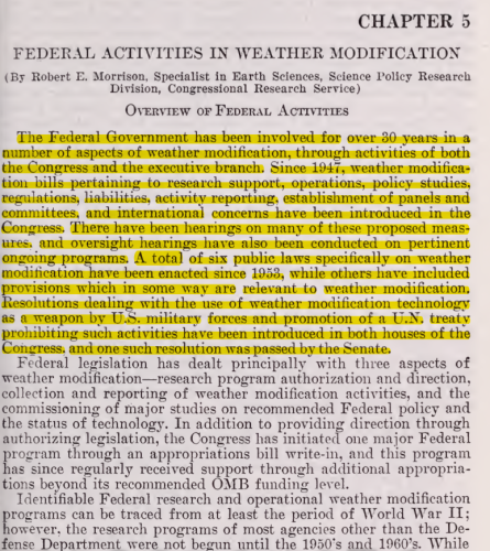
Then a Congressional document is revealed that deals with government involvement in the weather:

Source: Weather Underground, AccuWeather,
GeoEngineering / Toxic Air
___________________________________
What would happen if you woke up to hazy skies and little sunshine?
With all the safeguards on the quality of our air, Arizonans are mandated by laws to have their cars emissions checked, farmers have to water their fields to keep down the dust, and a buearcracy (AZ DEQ) was formed to keep track of air pollutants.
A lot of tax payer money, time, and fees to keep your air clean and safe.
Or is all the fuss just a ruse? How about Exhibits 1 - 6:


Beautiful blue skies were seen until the planes began making lines, haze in the Phoenix sky this morning for the third straight day in a row.
If cities, towns, counties, and states do not care about the quality of the air by allowing geoengineering, then why waste everyone's time with bureaucracy upon bureaucracy in trying to control which you do not care about?
Before the toxic lines in the sky began their assault on Phoenix, Arizona on Sunday, our weather forecast looked like this:

Even AccuWeather advised:

Sunday turned completely overcast instead of just partly cloudy because of the spray in the sky:

Yesterday turned into haze from a sunny day. Sunlight dimmed to an unnatural level around noon time. Only solar eclipses have made such a dent in solar radiation.
Right now, Phoenix is seeing this:

While the weather reporters are talking about a .5 inch of rain coming Thursday and into Friday, watch how Weather Underground has already compensated for the toxic geoengineering spraying:

So is this a conspiracy theory? Or is weather manipulation just a conspiracy?
Then a Congressional document is revealed that deals with government involvement in the weather:
Review the literature, watch the skies, and note the changes in the forecasts. What is happening is real. So look up and start a conversation.
Source: Weather Underground, AccuWeather,
Sunday, October 25, 2015
The Autumn Factor
Staff Writer, Nathaniel Diaz
Weather / Autumn___________________________________
With the shift toward winter, the weather fluctuates between hot and cool. Autumn is here and the cool evenings and mornings are a welcomed sight. The desert is getting a break from the hot temperatures of the blazing summer.
What can we expect?
Solar flares have been quiet while the filament releases have energized our planetary weather system that have lasted these couple of weeks creating warmer temperatures like the 90's for this week. See Suspicious Observers for more information:
Our local forecast appears to be such:
Forecast Discussion: The upper-level low pressure system that has brought active weather to central Arizona this week is finally beginning to move out of the area. This puts Arizona underneath a dry, northwesterly flow pattern. As drier air filters into the state, skies will be clear each day through Saturday. Temperatures will rebound, approaching 90°F by Saturday. Near-surface winds are also expected to be light and variable. The two main pollutants currently in the spotlight for this air quality forecast are ozone and PM-2.5. As more stagnant conditions take hold over the next few days, both of these pollutants have the potential to accumulate more near the ground. Clear skies also mean more sunlight for local ozone production and stronger nocturnal inversions for overnight PM-2.5 build-up. Since history shows us that Moderate ozone levels are uncommon in late October, ozone is expected to remain in the Good range. The outcome of PM-2.5 levels is a little more uncertain, however. We will keep PM-2.5 in the upper Good range for now and will reevaluate it tomorrow for the weekend. Check back on Friday for a closer look at the weekend's weather and air quality. Until then, have a good day! -M.Graves
For the rest of October, the Farmer's Almanac writes:
 Includes California, Nevada, Utah, Arizona
28th-31st. Unsettled, showery.
Our local community forecast for today through Halloween is:

Source: AQED, Farmer's Almanac, Weather Underground
Wednesday, August 26, 2015
Urban Heat Islands
Staff Writer, Nathaniel Diaz
Weather / Thermal Imaging___________________________________
When weather forecasters mention your city's heat island, do you just get the idea of one locale? Here is what those Urban Heat Islands look like:
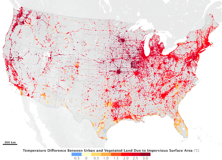
The urban heat island effect occurs primarily during the day, when urban impervious surfaces absorb more sunlight than the surrounding vegetated areas. Trees, grasses, and other vegetation naturally cool the air as a by-product of photosynthesis. They release water back into to the atmosphere in a process called evapotranspiration, which cools the local surface temperature in much the same way that sweat cools a person’s skin as it evaporates. Trees with broad leaves, like those found in many deciduous forests on the U.S. East Coast, have more pores to exchange water than trees with needles, and so have more of a cooling effect.
Read the article carefully as there is climate scientist propaganda mixed within the actual science.
Source: NASA
Sunday, August 23, 2015
HAARP Weather Warfare and Full Spectrum Dominance with Elana Freeland
Staff Writer, DB Holmes
Weather Modification / GeoEngineering______________________________________
HAARP weather warfare, chemtrails, and the meaning of full spectrum dominance is explored with author Elana Freeland. How Project Cloverleaf has evolved into disaster capitalism, and how Artificial Intelligence and transhumanism are part of the plot to maintain the hive mind of humanity is illuminated. From the space fence and ionosphere, to the atmosphere’s wave grid that can be utilized for humanity’s oppression and liberation–look to the heavens on this Buzzsaw, hosted by Sean Stone.
Source: Buzzsaw
Tuesday, August 18, 2015
Down The Rabbit Hole w/ Popeye, Guest: Jim Lee
Staff Writer, DB Holmes
GeoEngineering / Government___________________________________
On this edition of DTRH Popeye welcomes to the show for the first time Jim Lee of Climateviewer.com to discuss a few topics. The two of them get into: What Geoengineering is; Chemtrails and jet fuel; Jim’s chance to speak at the EPA hearing in Washington on August 11, 2015, and much more. Make sure to tune into this awesome broadcast.
Source: DTRHRadioArchives
Thursday, January 29, 2015
Wet Weather on its Way
Staff Writer, Nathaniel Diaz
Weather / Air Quality______________________________________
Welcome February weather this last week of January:
Forecast Discussion: The trough to the west is bearing down on Arizona bringing the overcast skies that we are currently seeing. We are confident that most of the state will receive a fair amount of precipitation, which will help improve air quality the next couple days. The Phoenix area will likely receive between a quarter to a half inch of rain with some areas getting even more. Rain should begin late tonight and last most of Friday with scattered showers continuing through Saturday as well. Conditions should begin clearing out late on Saturday with mostly sunny skies expected for Super Bowl Sunday. While the weather is looking good for the Super Bowl, the Phoenix Open will have to contend with wet conditions and temperatures in the lower 60's on Friday and Saturday. Remember, with all the festivities going on the next few days there will be more cars than usual on the road, so be safe while driving in the rainy conditions. Check back on Friday for a closer look at the weekend's weather and air quality.
Source: AIRNow
Tuesday, January 13, 2015
Onward marches the Great Pause
Staff Writer, Nathaniel Diaz
Climate Change / IPCC
_____________________________________
Source: Lord Mockton Foundation
Climate Change / IPCC
_____________________________________
Since October 1996 there has been no global warming at all (Fig. 1). This month’s RSS temperature plot pushes up the period without any global warming from 18 years 1 month to 18 years 2 months (indeed, very nearly 18 years 3 months). Will this devastating chart be displayed anywhere at the Lima conference? Don’t bet on it.
Sunday, January 4, 2015
Last Week On Mars
Staff Writer, Nathaniel Diaz
Mars / Space Weather___________________________________
This channel will evaluate the Suns effect on the Martian atmosphere as a weekly Martian weather report using the available data from the landers and orbiters now operating on and around mars. We will monitor of solar wind, coronal hole streams and coronal mass ejections and report their effects as they interact with the martian atmosphere
Source: Mars Observers
Tuesday, December 30, 2014
Second Hand Smoke Can Ruin Air Quality for the New Year
Staff Writer, Nathaniel Diaz
Air Quality / Weather_____________________________
Welcome to Winter 2015. A New Year's Eve storm will usher in cold, cold. cold, with a slight chance of rain for the Valley and other lower deserts.
The real concern is everyone polluting the air as the breathable air column descends and gets caught under the inversion layer. That means what goes up, fireplace smoke and fireworks, will be breathed in. Talk about second hand smoke!
So give the gift of breathing, do not use your fireplaces on New Year's Eve or Day. There is going to be enough smog in the Valley as it is. And, you could brighten someone's New Year by not sending them to the ER.
Here's the rest of the forecast:
Forecast Discussion: All eyes are on the approaching storm system to affect our region over the New Year's holiday. Latest weather model runs are in and the consensus is a colder and drier event; for the lower deserts. The moisture tap into our area peaks during Wednesday morning and afternoon. This is when cloud cover increases and the Phoenix Metro has the best shot at observing rain, particularly the higher terrain east and north. Ultimately, less rainfall and precipitation ending for the lower elevations around sunset New Year’s Eve will have consequences for air quality. This is a particularly cold storm that will lead to well below normal temperatures for much of the area, especially when winds turn light and cloud cover begins to break during the evening and overnight. Under these conditions, fireplace activity and fireworks can quickly contribute enough to PM-2.5 to warrant concerns for air quality. For instance, on New Year’s Eve 2012, similar weather conditions occurred when mostly clear skies, light winds, and cool temperatures developed during the evening. Despite relatively low PM-2.5 observations for much of the day, average hourly PM-2.5 concentrations leading into midnight surpassed 100 µg/m3 for some sites; pushing daily AQI values into the upper Moderate category for that day. Therefore, a PM-2.5 Health Watch has been issued for Wednesday, December 31st, 2014. Additionally, elevated PM-2.5 concentrations would carry over into New Year’s day. Subfreezing morning lows on Thursday will be slow to warm to near 50°F by afternoon. Light winds and long-lasting inversions are likely during this time. This means a PM-2.5 High Pollution Advisory is likely for New Year’s Day.
Source: AirNow
Thursday, December 25, 2014
What Happens to Air Quality When the NO BURN Days are Ignored*** Updated
Staff Writer, Nathaniel Diaz
Air Quality / Weather
___________________________________

Air Quality / Weather
___________________________________
Without wind and with the cold inversion layer, the Valley of the Sun's air becomes unhealthy, even hazardous to breathe.
There is really no excuse for this type of terrible air quality.
Please do not burn your fireplaces and let the rest of us breathe.
*************************************************
Update: the Air Quality worsens as the night progresses


*************************************************
Update: the Air Quality worsens as the night progresses
Wednesday, December 24, 2014
Air Quality Warning as Fireplaces Smoke Out Phoenix
Staff Writer, Nathaniel Diaz
Weather / Air Quality_________________________________
Air Quality for the next couple of days will be unhealthy and a challenge for those individuals with respiratory illnesses while everyone uses their fireplaces for festivities instead of necessity.

Forecast Discussion: The ridge off the west coast continues to influence our region bringing stable conditions. We have also seen drier air move into the area over the last 24 hours which will allow cooler minimum temperatures and stronger morning inversions. This will further help to trap particulates and increase their concentrations. The atmospheric stability along with increased burning activity associated with Christmas means today and Christmas will likely see concentrations of PM-2.5. The forecast for Christmas day was slightly more challenging due to some expected winds. A trough will be moving through the area tomorrow afternoon which will help with ventilation; however I expect light winds in the morning hours and PM-2.5 concentrations in the morning to be high enough that there will still be an exceedance even with some increased ventilation in the afternoon. I will admit that if winds are stronger than expected in the morning hours on Christmas, then PM-2.5 concentrations may be healthier than anticipated. Looking at the weather for the next few days, skies should be mostly sunny and temperatures will cool after the trough passes. Still no precipitation in the forecast due to the ridge that continues to sit off the west coast; hopefully we can get some strong enough lows to break down that ridge and bring us more rain.
Turn off the fireplace and turn on Youtube: 8 HOURS ✰ Best Fireplace HD 1080p video ✰ Relaxing fireplace sound ✰ Christmas fire, Full HD. Festivities saved.
You may just save a life.
Source: Airnnow
Subscribe to:
Posts (Atom)