Showing posts with label rain. Show all posts

Thursday, January 19, 2017

Winter Storms on the Prowl

Staff Writer, DL Mullan
Winter Storm / Weather
___________________________

Winter storms are set to hit Arizona with a one two three punch. Snow for the high country and rain for the central and lower deserts will start today, then continue with another storm on Friday and a weaker system on Monday.
Forecast Discussion: The initial wave of showers has arrived, albeit light showers. Doppler radar is indicating scattered rain entering the Valley as of 8:00 AM. The scattered nature of rain prevails today. Watch for a general west to east progression of showers tracking over the area. An improvement of air quality values commences when precip and breezes reach our monitors. Around a quarter inch of rain for the day is foreseen. Air quality values shift deeper into the Good AQI range tomorrow with continued wet and breezy conditions. Accumulations in the region do rise more quickly Friday afternoon through early Saturday. The second storm is more dynamical of the two. We could add another half inch plus in the lower deserts. Another feature with the latest storm is wind. Winds are to be quite gusty (20-30+ mph) out of the southwest ahead of and adjacent to the impending cold front. Had it not been for a wet winter to date and measurable rain falling in southeastern California and south-central Arizona in the present, there would have been concern for blowing dust threatening air quality concentrations. Not the case this time. Bring that coat if you are planning on being outside the rest of the week. A third storm reinforces cool weather and rain chances late Sunday/Monday. Any given day, afternoon temps reach low 60s at best.


Source: AirNOW,

Wednesday, June 29, 2016

The Monsoon and Unhealthy Ozone

Staff Writer, Nathaniel Diaz 
Weather / Air Quality
________________________________

Ozone will be a problem again in the unhealthy range. So people with respiratory issues should limit activity. Healthy people should take caution as well. 


Will the monsoon come and alleviate the unhealthy air quality?
Forecast Discussion: Ozone has been exceptionally high the past couple days as a monsoonal high pressure has persistently remained over the Four Corners region. This system has resulted in an easterly, upper-level flow over the Valley, which acts to "lock" ozone over central parts of the Valley and allows it to accumulate. Nine Valley monitors exceeded the health standard yesterday. Looking ahead, a ridge of high pressure is forecast to remain situated over the Southwest for the next several days. Consequently, the atmosphere over the Valley is expected to be stagnant and support ozone accumulation. Hence, the ozone High Pollution Advisory (HPA) has been extended into Thursday. It is likely that an HPA will be issued for Friday, depending on timing of thunderstorm activity. Regarding thunderstorms, thunderstorms are likely to develop each day over the higher terrain in southeast Arizona and to the north/northeast of Phoenix. Due to the very moist atmosphere over much of south central Arizona, these storms will have to the potential to reach the Valley. For today, there is agreement in high resolution models that a strong outflow could impact the Valley from the south later this afternoon. This would result in blowing dust impacting the Valley. Elevated PM-10 is thus possible this evening. Any rain will help to shut down PM-10. Blowing dust will continue to be a possibility each afternoon/evening this week. Check back tomorrow for the next air quality forecast...
Storms are expected around the metro area for the next few days and into the first of July.  


Hopefully these storms produce enough rain to clean the air, wet the land, and keep ozone at bay.


Source: AirNOWWeather Underground


Tuesday, October 27, 2015

Third Day of White Out Leaves Phoenix in a Toxic Haze

Staff Writer, DL Mullan
GeoEngineering / Toxic Air
___________________________________

What would happen if you woke up to hazy skies and little sunshine? 

With all the safeguards on the quality of our air, Arizonans are mandated by laws to have their cars emissions checked, farmers have to water their fields to keep down the dust, and a buearcracy (AZ DEQ) was formed to keep track of air pollutants.

A lot of tax payer money, time, and fees to keep your air clean and safe. 

Or is all the fuss just a ruse? How about Exhibits 1 - 6:


Beautiful blue skies were seen until the planes began making lines, haze in the Phoenix sky this morning for the third straight day in a row. 

If cities, towns, counties, and states do not care about the quality of the air by allowing geoengineering, then why waste everyone's time with bureaucracy upon bureaucracy in trying to control which you do not care about? 

Before the toxic lines in the sky began their assault on Phoenix, Arizona on Sunday, our weather forecast looked like this: 


Even AccuWeather advised: 


Sunday turned completely overcast instead of just partly cloudy because of the spray in the sky: 
Yesterday turned into haze from a sunny day. Sunlight dimmed to an unnatural level around noon time. Only solar eclipses have made such a dent in solar radiation.

Right now, Phoenix is seeing this:
While the weather reporters are talking about a .5 inch of rain coming Thursday and into Friday, watch how Weather Underground has already compensated for the toxic geoengineering spraying: 


So is this a conspiracy theory? Or is weather manipulation just a conspiracy?

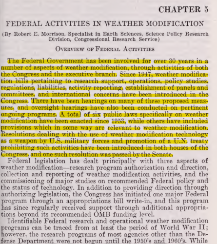
Then a Congressional document is revealed that deals with government involvement in the weather:
Review the literature, watch the skies, and note the changes in the forecasts. What is happening is real. So look up and start a conversation.


Source: Weather Underground, AccuWeather,

Monday, October 26, 2015

Engineering Earth, Exposing The Global Climate Modification Assault

Staff Writer, DL Mullan
GeoEngineering / Weather Modification
_____________________________________

Governments around the world have long since fully deployed global climate engineering on a scale that cannot truly be comprehended. They decided (without public knowledge or consent) that they had the right to use the atmosphere of our planet to serve their own agendas which amount to nothing less than weather and biological warfare. On August 14th, 2015, there was a major event in Northern California that was organized for the purpose of exposing and halting the global climate engineering programs that are decimating our planet and the entire web of life. Numerous experts spoke out at this event including attorneys, former government scientists, a former defense industry technician, former military personnel, a prominent Northern California Neurologist, and a CEO for one of the largest environmental and engineering consulting firms in the world. Approximately 1000 people attended this event. http://www.geoengineeringwatch.org/ma... The video below is the primary PowerPoint informational presentation given at the event, "Engineering Earth, Exposing The Global Climate Modification Assault". This presentation was given by Dane Wigington, lead researcher for geoengineeringwatch.org. The emcee for this important event was John B. Wells, radio host for the highly acclaimed "Caravan to Midnight" show. John works tirelessly toward revealing the truth for the common good. His participation in the Northern California event was of immense benefit to the cause of exposing geoengineering. My deepest appreciation to John, to all the speakers that participated and shared their knowledge, to each and every activist that contributed countless hours, and of course our gratitude to all those that attended the event. Individuals came from locations as far away as Valdez Alaska and St. Louis Missouri.

Source: GeoEngineering Watch

Sunday, October 25, 2015

The Autumn Factor

Staff Writer, Nathaniel Diaz
Weather / Autumn
___________________________________

With the shift toward winter, the weather fluctuates between hot and cool. Autumn is here and the cool evenings and mornings are a welcomed sight. The desert is getting a break from the hot temperatures of the blazing summer. 

What can we expect?

Solar flares have been quiet while the filament releases have energized our planetary weather system that have lasted these couple of weeks creating warmer temperatures like the 90's for this week. See Suspicious Observers for more information:


Our local forecast appears to be such: 
Forecast Discussion: The upper-level low pressure system that has brought active weather to central Arizona this week is finally beginning to move out of the area. This puts Arizona underneath a dry, northwesterly flow pattern. As drier air filters into the state, skies will be clear each day through Saturday. Temperatures will rebound, approaching 90°F by Saturday. Near-surface winds are also expected to be light and variable. The two main pollutants currently in the spotlight for this air quality forecast are ozone and PM-2.5. As more stagnant conditions take hold over the next few days, both of these pollutants have the potential to accumulate more near the ground. Clear skies also mean more sunlight for local ozone production and stronger nocturnal inversions for overnight PM-2.5 build-up. Since history shows us that Moderate ozone levels are uncommon in late October, ozone is expected to remain in the Good range. The outcome of PM-2.5 levels is a little more uncertain, however. We will keep PM-2.5 in the upper Good range for now and will reevaluate it tomorrow for the weekend. Check back on Friday for a closer look at the weekend's weather and air quality. Until then, have a good day! -M.Graves
For the rest of October, the Farmer's Almanac writes:

California, Nevada, Utah, ArizonaIncludes California, Nevada, Utah, Arizona
24th-27th. Clearing weather, turning colder.
28th-31st. Unsettled, showery.

Our local community forecast for today through Halloween is:


Source: AQED, Farmer's Almanac, Weather Underground

Monday, August 24, 2015

Rain Dispersal, Elections, and GeoEngineering

Staff Writer, Nicole Meyer-Greene
Weather Modification / Elections
__________________________________

With elections for the City of Phoenix slated for tomorrow, Tuesday, August 25th, a curious situation happened: the rain was postponed. As weather forecasters predicted rain Monday night but mostly into early Tuesday morning and afternoon, all of a sudden, that prediction was put on hold.

Where did the rain go? 


After days of blue skies, the lines returned. Coincidence? 

And who is paying for these expensive toxic weather modification days? The City of Phoenix, which is already in financial debt? The State of Arizona, ditto? Or the Joint Chiefs of Staff, who have plenty of budgeted funds thanks to policy papers like PNAC, or it's new name the Foreign Policy Initiative? 

Tomorrow's Propositions are full of United Nation's funding for Climate Change policies that are destructive to Americans, the environment, and government budgets. 

One thing is certain: GeoEngineering is making a mess of our skies, ozone layer, and weather. 

Don't let GeoEngineering make a mess of Phoenix more than it already has.


Thursday, January 29, 2015

WMO Expert Committee on Weather Modification Research

Staff Writer, Nathaniel Diaz
Weather Modification / Programs
_____________________________________


In this document, WHO admits that: "Weather Modification Around the World 42 Countries with active cloud seeding programs." 

Who GeoEngineers Arizona?

Source: WHO

Wet Weather on its Way

Staff Writer, Nathaniel Diaz 
Weather / Air Quality
______________________________________

Welcome February weather this last week of January: 
Forecast Discussion: The trough to the west is bearing down on Arizona bringing the overcast skies that we are currently seeing. We are confident that most of the state will receive a fair amount of precipitation, which will help improve air quality the next couple days. The Phoenix area will likely receive between a quarter to a half inch of rain with some areas getting even more. Rain should begin late tonight and last most of Friday with scattered showers continuing through Saturday as well. Conditions should begin clearing out late on Saturday with mostly sunny skies expected for Super Bowl Sunday. While the weather is looking good for the Super Bowl, the Phoenix Open will have to contend with wet conditions and temperatures in the lower 60's on Friday and Saturday. Remember, with all the festivities going on the next few days there will be more cars than usual on the road, so be safe while driving in the rainy conditions. Check back on Friday for a closer look at the weekend's weather and air quality.

Source: AIRNow

Tuesday, December 30, 2014

Second Hand Smoke Can Ruin Air Quality for the New Year

Staff Writer, Nathaniel Diaz
Air Quality / Weather
_____________________________

Welcome to Winter 2015. A New Year's Eve storm will usher in cold, cold. cold, with a slight chance of rain for the Valley and other lower deserts.

The real concern is everyone polluting the air as the breathable air column descends and gets caught under the inversion layer. That means what goes up, fireplace smoke and fireworks, will be breathed in. Talk about second hand smoke!

So give the gift of breathing, do not use your fireplaces on New Year's Eve or Day. There is going to be enough smog in the Valley as it is. And, you could brighten someone's New Year by not sending them to the ER.

Here's the rest of the forecast:
Forecast Discussion: All eyes are on the approaching storm system to affect our region over the New Year's holiday. Latest weather model runs are in and the consensus is a colder and drier event; for the lower deserts. The moisture tap into our area peaks during Wednesday morning and afternoon. This is when cloud cover increases and the Phoenix Metro has the best shot at observing rain, particularly the higher terrain east and north. Ultimately, less rainfall and precipitation ending for the lower elevations around sunset New Year’s Eve will have consequences for air quality. This is a particularly cold storm that will lead to well below normal temperatures for much of the area, especially when winds turn light and cloud cover begins to break during the evening and overnight. Under these conditions, fireplace activity and fireworks can quickly contribute enough to PM-2.5 to warrant concerns for air quality. For instance, on New Year’s Eve 2012, similar weather conditions occurred when mostly clear skies, light winds, and cool temperatures developed during the evening. Despite relatively low PM-2.5 observations for much of the day, average hourly PM-2.5 concentrations leading into midnight surpassed 100 µg/m3 for some sites; pushing daily AQI values into the upper Moderate category for that day. Therefore, a PM-2.5 Health Watch has been issued for Wednesday, December 31st, 2014. Additionally, elevated PM-2.5 concentrations would carry over into New Year’s day. Subfreezing morning lows on Thursday will be slow to warm to near 50°F by afternoon. Light winds and long-lasting inversions are likely during this time. This means a PM-2.5 High Pollution Advisory is likely for New Year’s Day.

Source: AirNow

Wednesday, July 30, 2014

GeoEngineering Daily Report, 7.30.14

Staff Writer, DL Mullan
Photographer, DL Mullan
__________________________________

The silver nuisance has returned to our fair skies. 

It is so nice that here in America that we cannot house, feed, or care for our people but we can pay for chemical companies to pollute our skyways. 

July 22nd, the lines began again. This time the eco-terrorists were high above placing lines above the monsoon clouds. Don't think your efforts went unnoticed. 

We also noticed how the monsoon took a hiatus when even the Farmer's Almanac had stated that we were in for heavy monsoonal action on those days. Why are we not being allowed our rain? For another polar vortex but for the summer in the east? 

All very good unanswered questions.

A short time later that week, AIRNow reported haze and grime in the skies over Southern Arizona. The government agency touted once again that the haze was somehow natural. Phoenix geoengineering watchers have seen these false reports as well.

As for our city today, tax money was again spent spraying toxins into the sky. 

Over our Southern Skies

More lines in the South

A Jet making a Fresh Track

These are NOT normal.

Isn't it time to get your local and state officials involved in this situation?

Tuesday, July 15, 2014

Monsoon Cool Down and Decent Air Quality, Week of July 15

Staff Writer, Nathaniel Diaz
Weather / Air Quality
___________________________________
Today's Air Quality
Forecast Discussion: Forecast models did very well with Sunday's storms in regards to timing and location. Areas in the southeast Valley are cleaning up this morning after severe weather rolled through the area. Reports of hail, downed trees, winds in excess of 60 mph and over an inch of rain in less than an hour came in as the storm moved west. Typically after a storm like that, the Valley is tapped of energy and the following day is a down-day. However, models are in agreement that we could see another round Monday afternoon. They differ slightly on whether storms move through the Valley or skirt metro area to the north and south, merging again in western Maricopa County. There could be isolated downpours, hazardous lightning, damaging winds, and hail. This will be the last chance for rain until next Sunday or Monday as the monsoon high moves to northern California. Much drier air moves into Arizona by Wednesday. Expect middle Moderate ozone levels through Wednesday. PM10 levels should be back in the Good range following Sunday's rain event and any subsequent precipitation on Monday.


Source: AIRNow, Weather Channel

Sunday, July 6, 2014

Monsoon 2014, Dust Storms, Flash Floods, and Air Quality Concerns

Staff Writer, DB Holmes
Weather / Air Quality
_________________________________

Welcome to Monsoon Season. This week and weekend are full of monsoon moisture. July 3rd, Phoenix and surrounding areas were hit by a dust storm, haboob, and thunder showers.

So baton down the hatches, it's going to be a bumpy ride especially with air quality being poor in the forecast.
Tomorrow's Air Quality
AN OZONE HEALTH WATCH HAS BEEN ISSUED FOR MONDAY, JULY 7, 2014… …A PM-10 HEALTH WATCH HAS BEEN ISSUED FOR MONDAY, JULY 7, 2014… Once the cloud cover erodes another round of thunderstorms is expected to develop over the higher terrain north and east of the Valley. The steering flow is similar to yesterday (weak out of the northeast) and storms will likely slowly propagate off the higher terrain into the lower elevations later this afternoon and evening. Gusty winds and chances for rainfall can be expected. Because of the northeast flow dust concerns are low. This does not hold true for tomorrow, as models are advertising another possible strong haboob coming from Pinal County during the early evening under east-southeasterly flow. Rainfall is possible, as well. The potential precipitation and the fact that Pinal County has recently observed more significant rainfall accumulation may lower the dust risk, but a PM-10 Health Watch for Monday still seems warranted. We will look at future model runs for any necessary adjustments. Also, ozone is already elevated at some sites and a more easterly flow over the Valley tomorrow can block ozone precursors and allow them to accumulate. The increase in traffic won’t help either. Therefore, an ozone health watch has been issued for Monday, as well.

July 2014
4th-7th. Monsoonal showers, still hot for parts of Arizona.
8th-11th. Changeable skies: mixed clouds, sun. Risk of a shower, thunderstorm.
12th-15th. Clouds, few widely scattered showers.
16th-19th. Warm, dry.
20th-23rd. Unusual heavy monsoonal storms Arizona.
24th-27th. Hot, dry.
28th-31st. Continued hot.

Source: Weather Channel, AIRNow, Farmer's Almanac,

Sunday, June 1, 2014

Excessive Heat, Summer Sun, No Dust

Staff Writer, DB Holmes
Weather / Air Quality
_______________________________

It is going to be a scorcher for the first week in June. An Excessive Heat Warning is out especially for tomorrow's 112F. No high winds or dust storms likely. No break from the summer heat as temperatures stay above 105F.
Today's Air Quality
Forecast Discussion: The Phoenix-area air quality was again in the Good range for all pollutants on Saturday. The approach of a trough of low pressure from the northwest has helped to clear the air by providing some good mixing. High pressure to the southeast will hold its position this week, keeping that trough to the north of Arizona as it slowly advances east this week. Daytime highs across the Valley may reach 110°F on Monday, shaving a degree or two through the week, and eventually "cooling" to 105°F. Expect ozone levels to push back into the lower Moderate range by Monday and Tuesday under sunny skies. Particulates should hold in the upper part of the Good range. We do not anticipate any significant dust events this week.


Source: AIRNow, Weather

Monday, May 26, 2014

Triple Digit Yo-Yo Heat Ready for Action

Staff Writer, DB Holmes
Weather / Air Quality
________________________________

Hot and somewhat dry. Dew points have been in the 40's while humidity has been averaging in the 30-40% range. Desert heat comes and goes this week but only showing how this summer will be: hot. Just hot.
Memorial Day's Air Quality
Forecast Discussion: A salute to the veterans who gave their lives serving our county - Happy Memorial Day! Air quality conditions have fared pretty well in recent days. The modeled forecast of possible dust outflow from storms southwest of the Valley on Friday did verify with storm development, but did not result in dust. In fact local PM10 levels are in the middle Good range. With high pressure surging over Arizona Monday through Wednesday, winds should remain mostly light, keeping the threat of dust out of the picture. Ozone concentrations, however, may remain in the middle Moderate range much of the week under sunny skies. Daytime temperatures in Phoenix will range from 105-108°F Monday through Wednesday.


May 2014

24th-27th. Changeable skies: mixed cloud, sun, possible shower. Cool temperatures.
28th-31st. Possible showers again.

June 2014

1st-3rd. Changeable skies: mixed clouds, sun. Risk of a shower.
4th-7th. Varying amounts of clouds, sun. Dry.


Source: AIRNow, Weather Channel, Farmer's Almanac  

Friday, May 23, 2014

Do You Want a Dust Storm with Dinner?

Staff Writer, DB Holmes
Weather / Air Quality
_________________________________

The start of the weekend looks good but there is the possibility of a dust storm from dry thunderstorms coming in from the west and southwest. Then Phoenix will be headed into the triple digits once again. A tropical storm is ramping up in the southwestern waters off Mexico. What will happen? Nothing so far in the forecast seems to indicate any problems from this tropical depression as it strengthens.

Still for those people with respiratory problems, stay inside with filtered air at any signs of dusty air.
Forecast Discussion: The lingering area of low pressure to the west finally opens up and and catches a ride on the main jet stream over the weekend. Before this happens, however, Arizona will see an influx of moisture into the eastern half of the state. Models also show possible dry thunderstorms developing in southwestern Arizona Friday afterno
Saturday's Air Quality Forecast
on near Yuma and Gila Bend. The outflow could generate some dust moving in all directions. The first PM10 monitor that would impacted in the Valley would be the Buckeye monitor. Models have the wind field (and possible dust) moving east across the Valley between 6 and 8 pm. This is the second consecutive day the models have had this solution. We have raised the PM10 forecast to reflect this possibility. Ozone levels may also increase on Saturday in response to Friday's outflow. The same model shows possible thunderstorm outflow moving south from Prescott into north Phoenix Saturday afternoon on the back side of the eastward-moving low pressure system. This would potentially affect the Surprise/Dysart/Sun City/north Peoria area the most. It's going to be a very active, interesting couple of days weather-wise which increase air quality uncertainty.


Source: AIRNow, Weather Channel 

Wednesday, May 21, 2014

Rain? You Don't Say

Staff Writer, DB Holmes
Weather / Air Quality
_____________________________________

Tomorrow the Valley of the Sun has a 30% chance of rain.
Forecast Discussion: Low pressure to the west will spin in place through much of the week. The southwest-to-northeast flow will keep the potential ozone and precursor train from southern California moving into Arizona. The good news is that smoke from southern California wildfires won't be much of an influence as crews have mostly subdued them. Local ozone levels continue to decrease steadily with highest levels in the lower Moderate range. With the churning trough of low pressure to the west, Arizona can expect gusty winds Tuesday and Wednesday. This could cause localized pockets of dust in the vicinity of recently disturbed soil. Overall maximum PM10 levels, however, should remain mostly in the Good range. Conditions improve Thursday as winds decrease.


Source: AIRNow, Weather Channel

Sunday, May 18, 2014

Instant Summer, Just Add Heat and Ozone

Staff Writer, DB Holmes
Weather / Air Quality
_________________________________

The heat gives us a break at the mid part of the week and then slowly builds back in as a cut off low spins away. For respiratory issues sufferers, the ozone has replaced dust and particulates in causing breathing difficulties. The ozone should return to a more normal range for this time of the year as clouds and cooler weather enter the picture this week.
May 19 Air Quality Forecast
Forecast Discussion: If the triple-digit heat came a little too early for you (104°F at Sky Harbor Friday and Saturday), take heart. Temperatures will "cool" to around 90°F by Wednesday as a trough of low pressure moves over Arizona. This trough will actually become cut off from the main flow, sitting over our area through next weekend as it eventually spins out and loses energy. This could eventually be good as far as wildfires go. Towards the end of the week, the low is expected to draw some moisture from the Gulf of Mexico into eastern Arizona. The mountains could see some showers next Saturday and Sunday. Regardless of the rain, the increased humidity should help reduce fire behavior. Ozone is the current topic of conversation. Yuma exceeded the 8-hour ozone health standard on Friday. Typically we'll see levels do the same in the Valley a day later. However, we were spared as the flow was more to the north-northeast rather than east-northeast. Unfortunately, Alamo Lake, Prescott, and Flagstaff all exceeded the standard on Saturday. Exceeding the ozone standard in those non-major-metropolitan areas is a classic case of ozone import from the west. Let's not forget that smoke from southern California may have played a role in enhancing the ozone development upstream. Looking forward, high clouds Sunday should keep ozone production down slightly. This may be just enough help to avoid exceeding the standard in Valley. Stronger winds develop Monday through Wednesday which should also help break up the invisible plume, decreasing the threat of elevated readings. Dust doesn't seem to be much of a concern for us this week, especially when moisture is drawn in later in the week.


Source: AIRNow, Weather Channel,

Saturday, May 17, 2014

Ozone Concern and Triple Digit Heat for the Desert Valley

Staff Writer, DB Holmes
Weather / Air Quality
____________________________________

Phoenix should have a quiet weather weekend as winds are subdued and temperatures remain hot. Ozone rose but now the westerly winds will pick up the smoke from the California wildfires. People with respiratory issues should take note.

Here is the rest of the forecast:
Forecast Discussion: Ozone levels soared into the upper Moderate range across the forecast area on Thursday, and that was without the help of southern California wildfire smoke. Now that the flow has switched out of the west, the likelihood of smoke-enhanced ozone affecting Arizona increases. In fact, locations north of the Valley (Prescott, Flagstaff) could see elevated concentrations the next several days. Locally, Valley concentrations will remain in the upper part of the Moderate range through Sunday. Winds will increase Sunday afternoon as another trough of low pressure approaches the region. This should break up the invisible daily plume of ozone, effectively lowering concentrations. PM10 levels should also remain in the Good range the next several days, increasing Sunday through early next week with stronger winds. Expect daytime temperatures to reach 102-104°F Friday through Sunday, decreasing Monday. Unfortunately, no rain is in the forecast for at least another 2 weeks.


Source: AIRNow 

Wednesday, May 7, 2014

Is it Summer Yet?

Staff Writer, DB Holmes
Weather / Air Quality
______________________________________

The triple digits are not far away but have been postponed for another few days. Air quality will improve as the wind subsides.
Today's Air Quality Forecast
The cold front responsible for kicking up winds and dust yesterday has cleared the state. All monitors yesterday recorded PM readings in the Moderate category. Elevated readings and some haze are still noticeable this morning, but breezy winds by afternoon will help disperse dust. Also, enough moisture and instability exists for light showers to develop over the higher terrain north and east of Phoenix during the afternoon. A cooler air mass has moved in and high temperatures in the upper 70s today are about 10 to 15 degrees below normal for early May. Temps will be somewhat slow to recover as Arizona remains under the influence of a broad area of troughing. Air quality improves by tomorrow, but ozone will continue to range in the upper Good to lower Moderate categories.

Source: AIRNOWWeather Channel,

Sunday, May 4, 2014

Giant Frogs, Giant Frogs, That's the Weather, Back to You

Staff Writer, DB Holmes
Weather / Air Quality
______________________________________

The heat is on right after a tiny three day vacation full of wind and potential dust. Is this the last gasp of spring weather making its way into the desert forecast? Or will the Valley of the Sun see more unsettled weather until Monsoon season begins? 
May 2014 Forecast for the Southwestern Region of the United States:
4th-7th. A few widely scattered showers.
8th-11th. Drier with some sunshine.
12th-15th. Clouds increase, turning warmer California, points east.
16th-19th. Fair, warmer.
20th-23rd. Scattered showers.
24th-27th. Changeable skies: mixed cloud, sun, possible shower. Cool temperatures.
28th-31st. Possible showers again.
The weather appears to be unstable with unseasonably low or high temperatures and storms that have moisture but leave Phoenix high and dry. Pretty soon, the forecast will call for giant frogs. Could the solar minimum be the cause of such erratic behavior in our weather patterns?
Forecast Discussion: Our hot and quiet weather this weekend will abruptly end early this week when the current ridge of high-pressure over the western U.S. flattens and is eventually replaced by a mid to upper-level trough of low-pressure. Generally, temps will go down, while southwesterly winds increase, peaking on Tuesday. Afternoon breezes up to 15 mph are expected to begin today and Monday. On Tuesday, widespread blowing dust across the Phoenix Metropolitan area is becoming more probable as models advertise sustained winds up to 25 mph with higher gusts. PM levels could reach the middle to upper Moderate range, but this may need to be adjusted higher depending on tomorrow’s model runs and how the storm is developing. An Air Pollution Health Watch for elevated PM-10 levels may be required for Tuesday (stay tuned). Ozone is also expected to reach the middle to upper Moderate range Monday and Tuesday as the storm imports precursors, but should fall back into the Good range in the wake of the storm’s passage. No precipitation is anticipated for the lower deserts, but high temps by Tuesday will be much cooler in the 80s. Enjoy the rest of the weekend and check back tomorrow for an updated forecast concerning the possible dust event on Tuesday!
The temperature forecast:


Last Year on this date:
High Temp: 94.1F
Low Temp: 66.6F
Average Temp: 80.1F
Dewpoint: 27.2F
Wind Speed: 6.8 Knots


Source: AIRNow, Weather Channel, Farmer's Almanac