Showing posts with label forecast. Show all posts

Tuesday, October 27, 2015

Third Day of White Out Leaves Phoenix in a Toxic Haze

Staff Writer, DL Mullan
GeoEngineering / Toxic Air
___________________________________

What would happen if you woke up to hazy skies and little sunshine? 

With all the safeguards on the quality of our air, Arizonans are mandated by laws to have their cars emissions checked, farmers have to water their fields to keep down the dust, and a buearcracy (AZ DEQ) was formed to keep track of air pollutants.

A lot of tax payer money, time, and fees to keep your air clean and safe. 

Or is all the fuss just a ruse? How about Exhibits 1 - 6:


Beautiful blue skies were seen until the planes began making lines, haze in the Phoenix sky this morning for the third straight day in a row. 

If cities, towns, counties, and states do not care about the quality of the air by allowing geoengineering, then why waste everyone's time with bureaucracy upon bureaucracy in trying to control which you do not care about? 

Before the toxic lines in the sky began their assault on Phoenix, Arizona on Sunday, our weather forecast looked like this: 


Even AccuWeather advised: 


Sunday turned completely overcast instead of just partly cloudy because of the spray in the sky: 
Yesterday turned into haze from a sunny day. Sunlight dimmed to an unnatural level around noon time. Only solar eclipses have made such a dent in solar radiation.

Right now, Phoenix is seeing this:
While the weather reporters are talking about a .5 inch of rain coming Thursday and into Friday, watch how Weather Underground has already compensated for the toxic geoengineering spraying: 


So is this a conspiracy theory? Or is weather manipulation just a conspiracy?

Then a Congressional document is revealed that deals with government involvement in the weather:
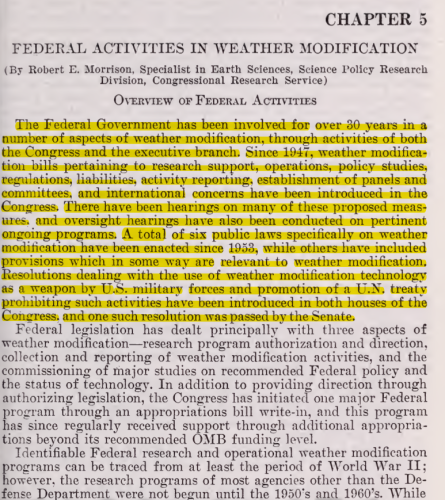
Review the literature, watch the skies, and note the changes in the forecasts. What is happening is real. So look up and start a conversation.


Source: Weather Underground, AccuWeather,

Sunday, October 25, 2015

The Autumn Factor

Staff Writer, Nathaniel Diaz
Weather / Autumn
___________________________________

With the shift toward winter, the weather fluctuates between hot and cool. Autumn is here and the cool evenings and mornings are a welcomed sight. The desert is getting a break from the hot temperatures of the blazing summer. 

What can we expect?

Solar flares have been quiet while the filament releases have energized our planetary weather system that have lasted these couple of weeks creating warmer temperatures like the 90's for this week. See Suspicious Observers for more information:


Our local forecast appears to be such: 
Forecast Discussion: The upper-level low pressure system that has brought active weather to central Arizona this week is finally beginning to move out of the area. This puts Arizona underneath a dry, northwesterly flow pattern. As drier air filters into the state, skies will be clear each day through Saturday. Temperatures will rebound, approaching 90°F by Saturday. Near-surface winds are also expected to be light and variable. The two main pollutants currently in the spotlight for this air quality forecast are ozone and PM-2.5. As more stagnant conditions take hold over the next few days, both of these pollutants have the potential to accumulate more near the ground. Clear skies also mean more sunlight for local ozone production and stronger nocturnal inversions for overnight PM-2.5 build-up. Since history shows us that Moderate ozone levels are uncommon in late October, ozone is expected to remain in the Good range. The outcome of PM-2.5 levels is a little more uncertain, however. We will keep PM-2.5 in the upper Good range for now and will reevaluate it tomorrow for the weekend. Check back on Friday for a closer look at the weekend's weather and air quality. Until then, have a good day! -M.Graves
For the rest of October, the Farmer's Almanac writes:

California, Nevada, Utah, ArizonaIncludes California, Nevada, Utah, Arizona
24th-27th. Clearing weather, turning colder.
28th-31st. Unsettled, showery.

Our local community forecast for today through Halloween is:


Source: AQED, Farmer's Almanac, Weather Underground

Thursday, January 29, 2015

Wet Weather on its Way

Staff Writer, Nathaniel Diaz 
Weather / Air Quality
______________________________________

Welcome February weather this last week of January: 
Forecast Discussion: The trough to the west is bearing down on Arizona bringing the overcast skies that we are currently seeing. We are confident that most of the state will receive a fair amount of precipitation, which will help improve air quality the next couple days. The Phoenix area will likely receive between a quarter to a half inch of rain with some areas getting even more. Rain should begin late tonight and last most of Friday with scattered showers continuing through Saturday as well. Conditions should begin clearing out late on Saturday with mostly sunny skies expected for Super Bowl Sunday. While the weather is looking good for the Super Bowl, the Phoenix Open will have to contend with wet conditions and temperatures in the lower 60's on Friday and Saturday. Remember, with all the festivities going on the next few days there will be more cars than usual on the road, so be safe while driving in the rainy conditions. Check back on Friday for a closer look at the weekend's weather and air quality.

Source: AIRNow

Tuesday, July 15, 2014

Monsoon Cool Down and Decent Air Quality, Week of July 15

Staff Writer, Nathaniel Diaz
Weather / Air Quality
___________________________________
Today's Air Quality
Forecast Discussion: Forecast models did very well with Sunday's storms in regards to timing and location. Areas in the southeast Valley are cleaning up this morning after severe weather rolled through the area. Reports of hail, downed trees, winds in excess of 60 mph and over an inch of rain in less than an hour came in as the storm moved west. Typically after a storm like that, the Valley is tapped of energy and the following day is a down-day. However, models are in agreement that we could see another round Monday afternoon. They differ slightly on whether storms move through the Valley or skirt metro area to the north and south, merging again in western Maricopa County. There could be isolated downpours, hazardous lightning, damaging winds, and hail. This will be the last chance for rain until next Sunday or Monday as the monsoon high moves to northern California. Much drier air moves into Arizona by Wednesday. Expect middle Moderate ozone levels through Wednesday. PM10 levels should be back in the Good range following Sunday's rain event and any subsequent precipitation on Monday.


Source: AIRNow, Weather Channel

Sunday, May 11, 2014

Dusty, Unhealthy Air Quality from the Baja to Four Corners Region

Staff Writer, DB Holmes
Weather / Air Quality 
_________________________________

A windy day across the state of Arizona. Dusty, unhealthy, and opaque air led to exceeding the air quality standards. This morning as dawn rose the air looked like fog. Upon smelling the air, one knew something was not right with the air.
Today's Unheathly Air
Forecast Discussion: Another dry cold front is currently marching through Arizona. Stronger winds along and ahead of the cold front have kicked up an impressive plume of dust, stretching from the northern Gulf of California to the Four-Corners region! The dust is being carried west to east with the western extent now entering Maricopa County. Overall, the dust plume now seems to be dissipating. Visibility has improved compared to early morning readings, but additional dust is still possible today under gusty winds this afternoon. The large amount of long-range dust transport overnight from the lower deserts of southeastern California and Arizona have pushed PM-10 readings into the Unhealthy category. Very high hourly average PM-10 concentrations this morning will likely result in exceedances of the federal standard at multiple monitors today. People should consider limiting outdoor physical activity due to unhealthy air quality. For tomorrow and Tuesday, breezy conditions persist, especially on Tuesday, but the direction turns more northeasterly allowing PM concentrations to fall into the upper Good to lower Moderate category. As the disturbance clears the area, ozone will drop with levels remaining near or slightly above Moderate thresholds. Clear skies and high temps in the mid 80s to lower 90s are expected.
Weather Conditions for this week:


More wind on Tuesday and a chance of sprinkles at the start of next week. A gradual increase in temperatures until triple digits dominate the long range forecast until September.

Source: AIRNow, Weather Channel

Wednesday, April 30, 2014

Hold onto Your Hats, It's Going to be a Windy Ride

Staff Writer, DB Holmes
Weather / Air Quality
____________________________________

Wind, wind, and more wind... is this Arizona? Triple digits this weekend could end that debate. So get out the pool supplies and water launchers, summer is here, even for just the weekend.
Forecast Discussion: Strong, gusty northerly winds will continue through midday Thursday as high pressure to the west is fighting to push the trough to the east of Arizona out of the way. That trough will pick up anchor on Thursday allowing the west coast ridge of high pressure to move over Arizona by Friday. Much lighter winds are expected Friday through the weekend under sunny skies. Daytime highs will also reach the middle to upper 90s on Saturday and Sunday. The air quality will also improve the next few days. Particulates have been held nicely in the Good range of the Air Quality Index (AQI) the past couple days due to northerly winds. Ozone, however, has pushed into the middle Moderate range at multiple Valley locations. Concentrations are starting lower this morning and we should see maximum ozone levels back in the Good range perhaps by today, but most likely by Thursday.
The weather forecast for the next week: 


Source: AIRNow, Weather Channel 

Friday, April 25, 2014

Geoengineering Daily Report, April 25

Staff Writer, Nicole Meyer-Greene
Photographer, DL Mullan
Geoengeineering / Forecast
_____________________________________

With an incoming storm and windy conditions, geoengineering may take a hiatus for a day or two as the storm is being seeded as chemicals have been sprayed for the last three days. 


Current conditions:

Tracer Elements for Radar Are Visible

Tracer Tick Tack Toe

Tracer Line Visible from Downtown Phoenix Going NonStop to North Phoenix

Tracer X Completed in North Phoenix from Downtown
Southern Skies Fair No Better

Persistent Contrails (Chemical Lines that become Solar Radiation Management Cloud Formations)

Forecast: For today, children and elderly, anyone with respiratory issues or compromised immune systems may want to stay inside in filtered air that cleans chemicals from indoor spaces to maintain a healthy air quality.

Action Plan: Call and write you City Council members, Mayors, State and Federal Representatives to end these destructive programs.

Thursday, April 24, 2014

Changes for the Weekend, Wind, Rain, and Unseasonable Temperatures

Staff Writer, DB Holmes
Weather / Air Quality
_____________________________________

More wind, a spatter of rain, and cooler temperatures for this weekend. Unseasonable and unusual weather but most likely the last Phoenix will see of below average temperatures until November. Saturday's light rain event might be all Phoenix sees in precipitation until the start of the Monsoon season the first week of July.
Forecast Discussion: The models have been pretty consistent with the next weather system slated to impact our forecast area later Friday through Saturay. Winds will increase out of the southwest between 10 and 20 mph Friday afternoon. There's a little break overnight, but winds will pickup again around noon on Saturday, gusting around 25 mph at times. Wednesday's episode did trigger some dust across part of the Valley with many monitors reaching the lower Moderate range of the Air Quality Index (AQI). This will likely happen again Friday and Saturday before the winds ultimately clear the air. Expect PM10 levels to reach the middle Moderate range Saturday. Ozone concentrations will likely push well into the Moderate range today ahead of the system, aided by some import from the west. Levels improve Friday through the weekend with stronger winds, especially when the winds turn out of the northwest on Sunday. Models still project highs in the low 70s on Saturday with a slight chance for a shower or two. Amounts won't be impressive, but the desert enjoys anything wet that the sky will provide. Highs push back into the low 90s by next Tuesday. 


Source: AIRNow, Weather Channel